
Knowing and understanding the layout and functionality of your land is crucial for successful management. The sooner you can get an idea of how the land works together as a whole, the quicker you can make good management decisions and the less likely you are to make costly mistakes.
One of the best tools you can use to get this kind of understanding is probably in your pocket right now – your smartphone. Services like Google Maps and Google Earth provide you with a satellite view of your property and can play an important role in your management plans.
The first thing I do when I am asked to evaluate a piece of property for it’s potential wildlife and habitat is to find it on Google Earth.
Seeing the property from overhead before I see it on the ground gives me a better understanding of where I am and what is around me.
But, when I am in the field I like to use Google Maps on my smartphone to drop pin certain locations, keep track of our movement, and mark areas of interest.
Using services like Google Earth and Google Maps can enhance your management strategies and allow you to make better, more informed decisions, which could save you time, energy, and money in the long run.
Here are a few key insights that you can gain about your property.
GET AN OVERVIEW OF LAYOUT AND FUNCTION
Getting a satellite image of your land helps you see your land as a whole ecosystem. When you know how it is laid out and what features are located where, you can begin to see how the land works together and how the wildlife are probably taking advantage of what it offers.
A birds eye view of the terrain will give you a basic concept of access points, where water is available and how it sheds, where denser forage bedding cover is located, and how you can spread out your hunting areas or space out and design your food plots.
Knowing these factors ahead of time can prevent you from spending time and money implementing irrelevant management practices such as planting millet in an area where you can’t control the water level, or setting up an observation area nex to a busy roadway.
These are all big picture items that need to be taken into account before any management strategies can be made and put into practice. And one key component that most people overlook is what the surrounding properties have to offer.
SEE WHAT BORDERING PROPERTIES OFFER
It’s not only important that you learn the layout of your land, but knowing what borders your property can play a key role in the management decisions that you make. And even though you may not have access to the bordering property you can still get a good understanding of how the land is being utilized and how to make it work in your favor.
If you’re dove hunting and the bordering property has a maze field but doesn’t have water, build a pond.
If you’re deer hunting next to a corn field that your neighbor has planted, provide escape and bedding cover.
You may think you need a food plot or some kind of water catchment to benefit your land’s habitat, but if the property that borders yours already has something established, or mother nature has already provided the perfect slough, don’t try to recreate it to be even better on your place.
Use it to your advantage. Do something that complements what is already there.
A good management plan starts broad and gets the big picture of the ecosystem of not only your land, but also what is around you and how you can best use what is there to develop the habitat for the wildlife you are wanting to attract.
NARROW YOUR FOCUS WITH THE NATURAL FLOW
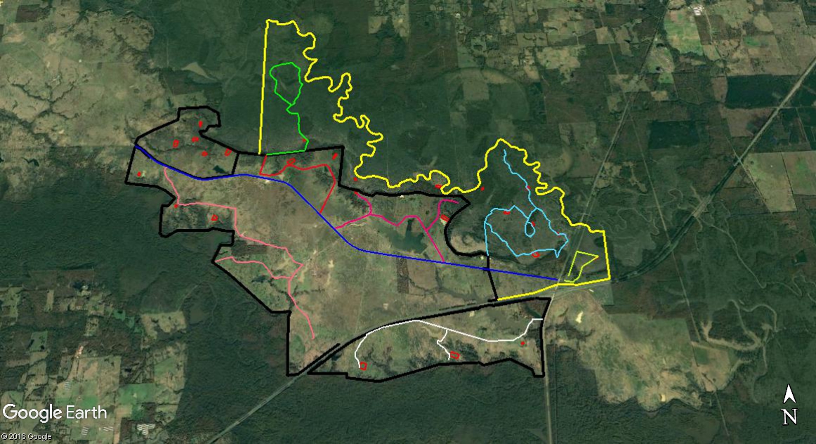
Once you have a good understanding of the ecosystem and terrain of your land as a whole you can begin to break down your property and look at it in sections (eco-regions).
Google Earth is a great tool when dividing your land into smaller eco-regions.
You can draw lines to highlight specific areas, access road and water sheds, and even label the names of observation areas and sloughs. Services like Google Earth Pro also allows you to measure the area of food plots to better determine acreage and how much herbicide, fertilizer, and seed is needed, or how many surface acres a slough or pond may be.
When dividing your property, you want to stay within the 25 acre range per eco-region.
If you have a larger property, you can divide it into 25 – 100 acre eco-regions.
For properties less than 50 acres, just use the area as a whole.
Using the natural flow of the property is the best way to divide it up. This is not only efficient, but it can help you better understand the different practices suitable for that eco-region.
Do you have pasture land that backs up to a hardwood bottom? If so, can you take half of that pasture and develop it into a shallow rice patty? Can you make part of the bottom land a green tree reservoir?
Does your property have a creek that somehow divides it? Will it flood to help fill up any shallow water areas? Does it have natural sloughs that you may not have to do anything to except spread some millet when the water is low?
Sometimes the best management is no management.
Seeing your land in smaller eco-regions will help you narrow your focus, creating the best management practices for that specific habitat.
Remember though, what is best in one eco-region isn’t necessarily what is best in another. While you are planning for them individually though, you still have to keep in mind the larger goal for the whole property.
Question: Have you studied your property using one of these services? What did you learn or find that you didn’t know was there and how did you use it the benefit of your management plan? Leave a comment below